|
First day.
1-7-17.
|
4-00 p.m. Left WEJH with Lieut. Gilman M.M.G.A.G.S.
Took South Easterly course as followed on Route to W.HAMDH.
Passed to the N.E. of low-lying Jebel 9 miles from WEJH.
5-15 p.m. Patch of white stones, 16 miles from WEJH.
5-45 p.m. Road forks here. Followed Easterly track whose bearing was 95 degs.
20 miles from WEJH.
5-50 p.m. W. MIA crossed.
21 miles from WEJH.
5-55 p.m. "Broken tree."
22 miles from WEJH.
6-05p.m. Track leads over stones and low hills, bearing 85 degs,
6-25 p.m. Straight ahead on a bearing of 120 degs. Drift sand on Jebel's side very noticeable.
6-30 p.m. Joined W. ABU AJAJ at "Y" Junction. Very soft sand here makes going difficult for heavy cars.
26 miles from WEJH.
7-00 p.m. Camped in W. ABU AJAJ and spent night there.
|
|
Second day.
2-7-17
|
4-20 a.m. Started. The Wadi here zig-zags a bit, its general direction being about 65 degs. Soft sand and shingle make the going heavy for cars.
5-00 a.m. Junction of tracks - one leading N.W. from here must be carefully avoided on the return journey as it is not passable for cars further on.
32 miles from WEJH.
5-15 a.m. Kept to left in Wadi.
5-20 a.m. Here tracks fork - the right one leading to the wells of BIR ABU AJAJ about a mile further on and the left track being the direct if watering not required at BIR ABU AJAJ. Took right track.
5-30 a.m. BIR ABU AJAJ.
38 miles from WEJH.
Stopped and drew water. One well not very full.
5-50 a.m. Started. Turned North up W. AJAJ for about 1000yards then turned at right angles due E. up stony wadi with slight incline. Going difficult owing to stones and cross ridges. Descended into open space.
6-00 a.m. Passed JEBEL ABU AJAJ on our left and keeping on a bearing of about 110 degs. up Wadi.
41 miles from WEJH.
6-30 a.m. Proceeding up Wadi we passed the two peaks of Jebel URR HATHAL on the North bank of the Wadi. From here I took a bearing on Northerly peak of Jebel RAAL which was 170 degs. Kept on a bearing of 130 degs. here.
6-50 a.m. From here I took bearings and found Jebel RAAL due South and Jebel AJAJ due North.
7-20 a.m. Descending a slight gradient J. SOLLAH now comes in to view. See sketch. Bearings here :J.RAAL 220 degs. J.SOLLAH 95 degs. :-
7-50 a.m. White chalky out-crop of stones was passed on right hand. Good landmark.
42 miles from WEJH.
8-30 a.m. Junction of Wadi KHAUTLA at foot of J.KHASHUB. Direction now changes to the North and we followed Wadi bearing 20 degs.
52 miles from WEJH.
8-40 a.m. Island Rock. Very stony bed of Wadi makes going very difficult and slow. General direction 30 degs.
54 miles from WEJH.
8-50 a.m. General direction North. Going very bad.
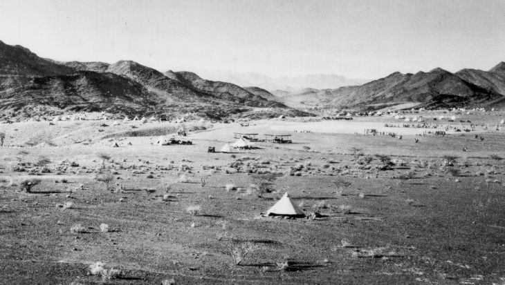
9-00 a.m. Took photograph No. 1, looking in a direction of 25 degs. Jebel SHALHUB may be observed in background
9-55 a.m. Going very bad. Picked up Camel track again, which comes out of the hills to the W. and apparently cuts off this difficult ground.
10-00 a.m. Approaching BIR KHOMBAH I took photograph No. 2 BIR KHOMBAH. One well very good water.
64 miles from WEJH.
10-30 a.m. Left KHOMRAH. Followed track leading 360 degs. over loose stones and boulders, going very difficult and bad.
11-50 a.m. Came to right bend. Turned off in a S.E. direction on a bearing of 120 degs.
72 miles from WEJH.
12 noon. Up stony Wadi on a bearing of 140 degs.
12-30 p.m. KHARRAH.
82 miles from WEJH.
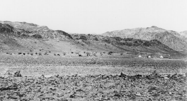
12-45 p.m. Entered very narrow rocky defile with a stream flowing down the centre disappearing and re-appearing among the shingle and rocks. Took photograph No. 3.
1-00 p.m. Difficult going up gorge owing to the large rocks. Bearing 140 degs.
1.20 p.m. Arrived at GAYADAH.
85 miles from WEJH.
|